Infrared Webcam Hack – Using infrared light to observe the world in a new way

Brief description

This set of three activities will enable students to understand the electromagnetic spectrum and observe infrared radiation through the modification of a cheap webcam. It will enable discussion of how infrared radiation can be used to obtain information that is not available using visible light. Students will also analyse satellite images providing them with a context to understand why it is useful to “see” in infrared. 

Subject Physics, Geography

Learning Objectives
  • Identify the different types of electromagnetic radiation
  • Describe different applications of infrared light
  • Use tools available on the internet to collect and analyse satellite data
  • Understand how infrared light can be used to monitor the health of vegetation
  • Identify false colour and true colour satellite images
Age range
12 – 16 years old
Time
approximately 30 minutes per activity
Resource available in:
Activity 1: Hacking the webcam
In this activity,  students will modify a webcam so that it sees in near-infrared light rather than in visible light. 
Equipment
  • 1 webcam with manual focus ring on the front
  • 1 drawing pin or a similar pin
  • Two pieces of exposed photographic film or a polarising filter large enough to cover the lens
  • Clear tape
  • Scissors
  • Computer
Activity 2: Looking at objects with an infrared camera
In this activity, students will look at different types of objects, observing each in both visible with their eyes and near-infrared light with the modify webcam. 
Equipment
  • Infrared camera (from activity 1)
  • Remote control
  • Led light
  • Candle
  • Healthy plant and fake plastic plant
Activity 3: Looking at the Earth in infrared light
In this activity, students will analyse satellite images. The activity introduces true colour images and compares them to false colour images that visualise near-infrared radiation. It provides students with a context so that they understand why it is useful to “see” in near-infrared.

Did you know?

The European Space Agency (ESA) has helped develop lots of satellites that use different types of cameras for looking at Earth. A group of missions called the Sentinels aim to improve our understanding and management of the Earth’s environment. One of the missions is called Sentinel-2 and consists of two twin satellites. The cameras onboard the
satellites take images in visible as well as in infrared light, and they cover the whole planet every five days! Sentinel-2 can be used to monitor plant growth, map changes in land cover, and monitor the world’s forests. 

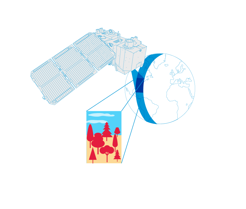
The Power of Earth Observation

We are all intricately interconnected to our Earth – from the trees that provide us with oxygen, to the natural sources that shape our landscape. ESA’s Earth observation programme is at the forefront of monitoring...

Land-use change

Satellite images enable us to document changes in land use very precisely. Discover how satellites provide information about land use on a global scale. Video by ESERO Germany (in English).

Astro farmer

Brief description:In this set of six activities, students will investigate which factors affect plant growth, and relate these factors to...

Helping to manage water

Discover how satellites can help collecting information on water resources at over large areas.
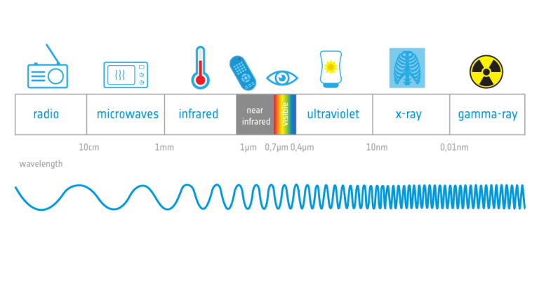
Ocean views

Ice and snow can be a hot topic when talking about climate. The polar regions are very fragile and can tell us a lot about how Earth’s climate is changing. Andrew Shepherd of the University...