Climate Detectives Projects 2022-2023
Project title: Biological chamber
Team: Cultura Cientifica 4º ESO Martín Rivero
IES Martin Rivero Ronda (Málaga) Spain 25 Student’s age: 14-15 years old
Is it possible to measure the health of a plant, after various weather conditions, using infrared light? – How is the health of a known mountain range, such as the Serranía de Ronda and Sierra Bermeja?
– ¿Es posible medir la salud de una planta, después de diversas condiciones meteorológicas, utilizando luz infrarroja? – ¿Cómo es la salud de una serranía conocida, como la Serranía de Ronda y Sierra Bermeja?

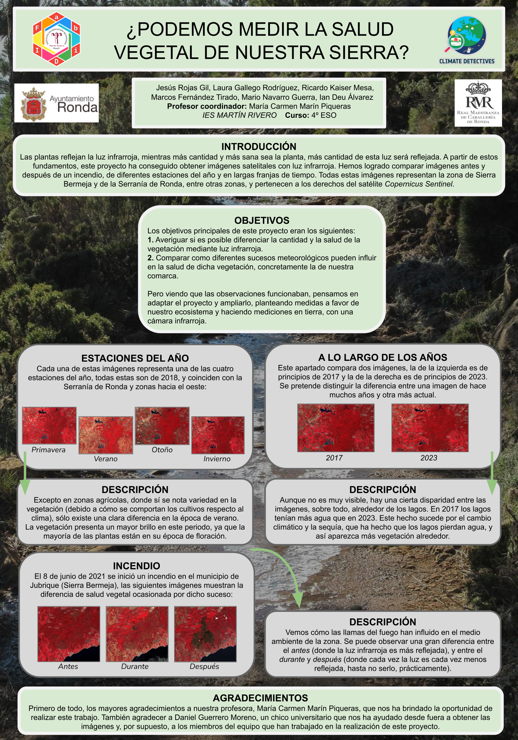
The intention was to use ground and satellite measurements with infrared light to measure the health of the plants, having gone through different weather conditions. The images obtained were then compared to see the difference between each other. The result was that we are able to differentiate plant health with infrared light, at least from satellites. And we started to investigate the health of the region we live in.
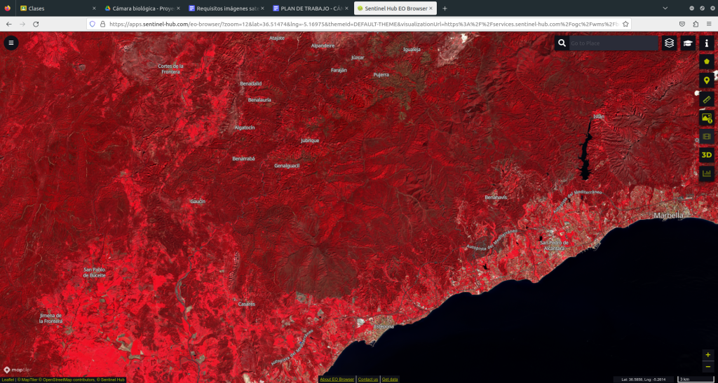
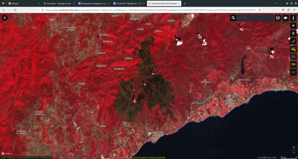
In our region, using satellite measurements we discovered a disaster that happened about 2 years ago, a fire, which we investigated and saw that there is a big difference, because now there are hardly any plants in that area.
We also notice a difference depending on the seasons of the year in which the photos are taken and the time that passes between each image obtained.
La intención era utilizar medidas en tierra y satelitales con luz infrarroja para medir la salud de las plantas, habiendo pasado diferentes condiciones meteorológicas. Luego, las imágenes obtenidas se compararon para ver la diferencia entre cada una. Obtuvimos como resultado que si somos capaces de diferenciar la salud de las plantas con luz infrarroja, al menos satelitalmente. Y empezamos a investigar sobre la salud de la comarca en la que vivimos.
Sobre nuestra comarca, utilizando medidas satelitales descubrimos un desastre que ocurrió hace alrededor de 2 años, un incendio, del cual investigamos y vimos que hay una gran diferencia, ya que ahora no existen apenas plantas en esa zona.
Incluso también notamos diferencia según las estaciones del año en la que las fotos sean tomadas y del tiempo que pase entre cada imagen obtenida.
we achieved our first objective, i.e. we managed to answer the questions we asked ourselves at the beginning of the project.
It is true that we can measure the health of vegetation using infrared light, and we can also learn more about our region and the plants that inhabit it, about their health and how they are organised.
We then look at how climate can influence vegetation, both for the better and for the worse.
conseguimos nuestro primer objetivo, es decir, logramos responder las preguntas que nos hicimos al principio del proyecto.
Sí es cierto que podemos medir la salud de la vegetación utilizando luz infrarroja y, también, logramos conocer más sobre nuestra comarca y las plantas que la habitan, sobre su salud y cómo está organizada.
Entonces, observamos cómo puede influir el clima en la vegetación, tanto para bien como para mal.
We now have two new objectives for the continuation of the project:
– Moving the observations to a more physical environment, with measurements on the ground. This would be possible through the use of a webcam, which, after some processing, would be able to measure in infrared light.
– To propose measures to help with the environment in our county, if we know where the problem is, thanks to satellite imagery, it would be much easier to eradicate it.
Ahora nos planteamos dos nuevos objetivos para continuar con el proyecto:
– Trasladar las observaciones a un ambiente más físico, con mediciones en tierra. Esto sería posible gracias al uso de una cámara web, que después de algún tratamiento, sería capaz de medir en luz infrarroja.
– Plantear medidas para ayudar con el ambiente de nuestra comarca, si sabemos dónde está el problema, gracias a las imágenes satelitales, sería mucho más fácil erradicarlo.
This project was automatically translated into English.
Projects are created by the teams and they take the full responsibility of the shared data.
← All projects